The Banaras visit is behind me now, and am back to the humdrum of daily life. Meanwhile the bandwagon of elections for the 16th Lok Sabha was set rolling yesterday. Six parliamentary constituency went to the polls in the first phase of polling. There is a sense of occasion - the biggest democratic exercise in human history is on its way. On average the turnout in the first phase of elections (75% in 5 seats in Assam and 84% in one seat in Tripura) is a few percentage points higher than 2009 . Though an early indicator, if this (higher turnout) is a precursor to what will happen in the rest of the country, then together with the 100 million incremental registered voters in 2014, it makes for a very interesting prospect. Suffice to say that this election is ripe with possibilities. In the effort to try to understand what 2014 has to offer, understanding the political geography of the country and what happened the last time when the nation went to vote are possibly good starting points. Also 2009 is the only election we have had since the last round of delimitation in 2007, hence some merit in starting with a quick look at the political geography before following it up with what happened in 2009.
The following graphic takes a quick look at the political geography of India, with the 35 states/union territories and 543 constituencies - the geographical and demographic diversity of the country is on display in all its grandness.A quick glance tells us about the distribution on population of the countries. The density of constituencies in the doaba region(between the Ganga and Yamuna) of UP and along the Ganga in Bihar and West Bengal contrasts sharply with the sparser distribution in the mountains to the north, the deserts in the west and the forests in the center . The largest constituencies (Ladakh, Kachchh, Barmer are orders of magnitude bigger than the smallest ones (North Kolkata and South Mumbai).
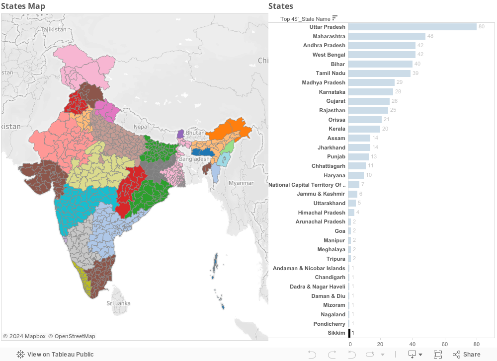
Worth noting is the natural hierarchy of states in terms of electoral importance. Just the top 6 states (UP, Maharashtra, West Bengal, Andhra Pradesh, Bihar and Tamil Nadu) constitute well over 50% of the total seats. It would be fair to say that no national party/coalition can hope to form a government in the center without a strong performance in at least 3 (ideally UP+2) of these states. With 80 seats, the result in UP alone has often had a strong direct import on who forms the government in the center.
Similarly the top 12 states (top 6 + MP, Karnataka, Gujarat, Rajasthan, Orissa,Kerela) constitute 420 or ~ 80% of the total seats, for all practical purposes National elections are won or lost in these states.
Out of the 543 seats of the Lok Sabha seats are reserved for the scheduled castes and seats are reserved for the scheduled tribes. The below graphic shows the distribution of seats for scheduled castes and tribes across the country. As we can see, the scheduled caste reserved seats are almost uniformly spread across the country while the scheduled tribes seats are concentrated in the forests of central India and the hilly regions of the north east.

Lastly worth mentioning here is that looking at a large states like Uttar Pradesh as a monolith may be seen as analytical oversimplification, and rightly so. Ideally the larger states should be split into smaller political regions for a more nuanced analysis. For example UP can be split into Rohilkhand, Awadh, Purvanchal, Bundelkhand and the Doab (region between Ganga and Yamuna), similarly Andhra Pradesh into Telengana, Rayalseema and Coastal Andhra and Maharashtra into metropolitan Mumbai, Konkan and Vidharba.
Just a little more work for the data wrangler!
The following graphic takes a quick look at the political geography of India, with the 35 states/union territories and 543 constituencies - the geographical and demographic diversity of the country is on display in all its grandness.A quick glance tells us about the distribution on population of the countries. The density of constituencies in the doaba region(between the Ganga and Yamuna) of UP and along the Ganga in Bihar and West Bengal contrasts sharply with the sparser distribution in the mountains to the north, the deserts in the west and the forests in the center . The largest constituencies (Ladakh, Kachchh, Barmer are orders of magnitude bigger than the smallest ones (North Kolkata and South Mumbai).
Worth noting is the natural hierarchy of states in terms of electoral importance. Just the top 6 states (UP, Maharashtra, West Bengal, Andhra Pradesh, Bihar and Tamil Nadu) constitute well over 50% of the total seats. It would be fair to say that no national party/coalition can hope to form a government in the center without a strong performance in at least 3 (ideally UP+2) of these states. With 80 seats, the result in UP alone has often had a strong direct import on who forms the government in the center.
Similarly the top 12 states (top 6 + MP, Karnataka, Gujarat, Rajasthan, Orissa,Kerela) constitute 420 or ~ 80% of the total seats, for all practical purposes National elections are won or lost in these states.
Out of the 543 seats of the Lok Sabha seats are reserved for the scheduled castes and seats are reserved for the scheduled tribes. The below graphic shows the distribution of seats for scheduled castes and tribes across the country. As we can see, the scheduled caste reserved seats are almost uniformly spread across the country while the scheduled tribes seats are concentrated in the forests of central India and the hilly regions of the north east.
Lastly worth mentioning here is that looking at a large states like Uttar Pradesh as a monolith may be seen as analytical oversimplification, and rightly so. Ideally the larger states should be split into smaller political regions for a more nuanced analysis. For example UP can be split into Rohilkhand, Awadh, Purvanchal, Bundelkhand and the Doab (region between Ganga and Yamuna), similarly Andhra Pradesh into Telengana, Rayalseema and Coastal Andhra and Maharashtra into metropolitan Mumbai, Konkan and Vidharba.
Just a little more work for the data wrangler!
No comments:
Post a Comment