I kind of skipped the post-modern history of the state almost entirely, and admittedly a lot has happened in Karnataka since unification which has implications on the politics of the state today. However at this point of time I think it necessary to delve deeper into the geography of the state, understanding the lay of the land, getting my bearings straight. So with that, onto a geography 101 for the state, with the promise to return to the post-modern history bit.
Karnataka is one of the nine coastal states of India, bordered by the Arabian Sea on its west. The coastal strip that borders the sea, is about 50 kms wide and has abundant rainfall. The western ghats separate the coastal plain from the the interior parts of the state, the dry, semi-arid parts of the deccan plateau with low humidity and rainfall.
While the northern interior parts of Karnataka which includes the districts of Belgaum, Bidar, Bijapur, Bagalkot, Haveri, Gadag, Dharwad, Gulbarga, Koppal, Bellary and Raichur have an average rainfall of as low as 70cms, the coastal districts have as high as 350 cms with the southern districts receiving marginally better rainfall then the north.
In the arid interiors of the state, water, or the lack of it, is a key part of the social and political discourse. The long standing disputes over the waters of the Krishna and the Kaveri are a testament to this.
Administratively Karnataka is divided into 30 districts. The tableau graphic below shows these districts. (Note - the graphic does not represent the three latest additions to the list of districts namely Chikballapur (by dividing Kolar) , Ramanagara (By Dividing Bangalore Rural) and Yadgir (from Gulbarga)). I am trying to get my hands on the latest shape-files. Will refresh this when I find it.
The Karnataka Assembly has 224 constituencies. distributed across the various districts of the state as shown in the graphic. The district of Bangalore constitutes the largest number of constituencies (24) followed by Belgaum (18) and Mysore,Tumkur at 11.
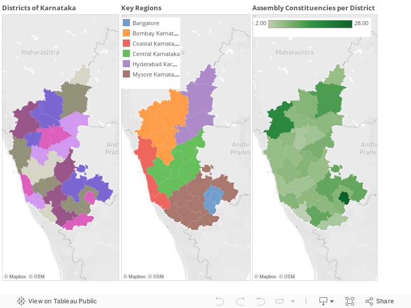
Now like it or not, the practice of psephology thrives on dividing areas into distinct regions based on a variety of factors to facilitate analysis . In the case of Karnataka, this division is done by most psephologist as shown in the image above. The basis of this is primarily around where these regions belonged to before integration. So Hyderabad Karnataka, has parts of Karnataka that came from the erstwhile princely states of Hyderabad, Bombay Karnataka has areas which came from the Bombay Presidency and Coastal Karnataka has the coastal districts that came from the erstwhile Madras presidency. The practice of calling out Bangalore as a separate region is recent by most accounts primarily due to the number electoral of might of Bangalore post delimitation ( the greater Bangalore region accounts for as many as 36 seats.
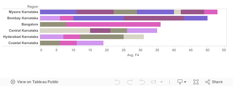
Perhaps useful at this stage to point out the relative importance of the empirical regions that we just defined in the larger arithmetic of the state. As is shown the following graphic what we defined as Mysore Karnataka leads the list with 53 assembly constituencies closely followed by Bombay Karnataka with 50. Bangalore (36), Central Karnataka(33) and Hyderabad Karnataka(31) each have 30 odd seats while Coastal Karnataka brings in 19 seats.
To close this post, analysts in all fields are often accused of overdoing it and psephologist should not be an exception. however we have come across some of the historical and geographical reasons for such a segmentation. An analysis of past election results can perhaps lay some light on whether it really makes sense.
No comments:
Post a Comment